


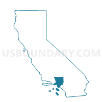
Voting District 56330, Los Angeles County, California
About
Outline

Summary
| Unique Area Identifier | 533736 |
| Name | Voting District 56330 |
| County | Los Angeles County |
| State | California |
| Area (square miles) | 0.02 |
| Land Area (square miles) | 0.02 |
| Water Area (square miles) | 0.00 |
| % of Land Area | 100.00 |
| % of Water Area | 0.00 |
| Latitude of the Internal Point | 34.12465330 |
| Longtitude of the Internal Point | -117.88081940 |
Maps


Graphs
Select a template below for downloading or customizing gragh for Voting District 56330, Los Angeles County, California


Neighbors
Neighoring Voting District (by Name) Neighboring Voting District on the Map
- Voting District 11380, Los Angeles County, CA
- Voting District 11389, Los Angeles County, CA
- Voting District 56261, Los Angeles County, CA
- Voting District 56309, Los Angeles County, CA
- Voting District 56336, Los Angeles County, CA
Top 10 Neighboring County Subdivision (by Population) Neighboring County Subdivision on the Map
Top 10 Neighboring Place (by Population) Neighboring Place on the Map
Top 10 Neighboring Unified School District (by Population) Neighboring Unified School District on the Map
Top 10 Neighboring State Legislative District Lower Chamber (by Population) Neighboring State Legislative District Lower Chamber on the Map
Top 10 Neighboring State Legislative District Upper Chamber (by Population) Neighboring State Legislative District Upper Chamber on the Map
Top 10 Neighboring 111th Congressional District (by Population) Neighboring 111th Congressional District on the Map
Top 10 Neighboring Census Tract (by Population) Neighboring Census Tract on the Map
- Census Tract 4040, Los Angeles County, CA (4,474)
- Census Tract 4009, Los Angeles County, CA (4,086)
- Census Tract 4042.02, Los Angeles County, CA (3,366)
- Census Tract 4039.01, Los Angeles County, CA (3,110)